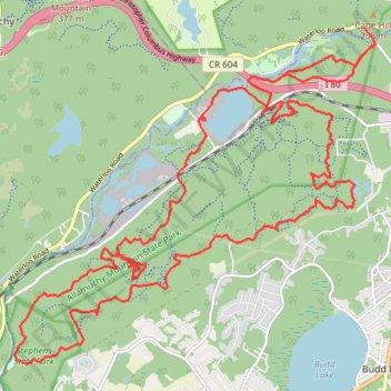
Stephens State Park
- Distance: 34.6 Km
- Elevation gain: 688 m
- Maximum elevation: 359 m
- Elevation loss: 684 m
- Minimum elevation: 192 m
- Moving time: 3 h 26 m
- Moving speed: 10.1 Km/h
- Maximum speed: 28.1 Km/h
- Total time: 4 h 5 m
- Global speed: 8.4 Km/h
Interactive trail map
Trail profile
- Distance: 34.6 Km
- Elevation gain: 688 m
- Maximum elevation: 359 m
- Elevation loss: 684 m
- Minimum elevation: 192 m
- Moving time: 3 h 26 m
- Moving speed: 10.1 Km/h
- Maximum speed: 28.1 Km/h
- Total time: 4 h 5 m
- Global speed: 8.4 Km/h
About this trail
Name: Stephens State Park trail, distance, elevation, map, profile, GPS track
Coordinates: 40.87189 -74.80536 40.92077 -74.73579
Other hiking, mountain biking, running and outdoor activity trails
Click on a trail to view its statistics, map and profile.
Allamuchy E-Mountain Bike Ride
United States > New Jersey > Morris County > Mount Olive
Allamuchy Mountain
Distance: 27.1 Km • Elevation gain: 544 m • Maximum elevation: 371 m
Allamuchy Mountain State Park
United States > New Jersey > Sussex County > Byram Township
Distance: 27.5 Km • Elevation gain: 444 m • Maximum elevation: 355 m
Best Of Deer Park
United States > New Jersey > Morris County > Mount Olive
Distance: 31.8 Km • Elevation gain: 621 m • Maximum elevation: 341 m