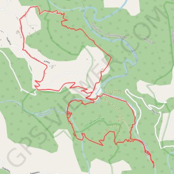
Željine - Visočka Banja - Đedovac - Rastovac
- Distance: 9.9 Km
- Elevation gain: 659 m
- Maximum elevation: 852 m
- Elevation loss: 659 m
- Minimum elevation: 589 m
Interactive trail map
Trail profile
- Distance: 9.9 Km
- Elevation gain: 659 m
- Maximum elevation: 852 m
- Elevation loss: 659 m
- Minimum elevation: 589 m
About this trail
Name: Željine - Visočka Banja - Đedovac - Rastovac trail, distance, elevation, map, profile, GPS track
Coordinates: 43.63743 19.89810 43.65559 19.91903
Other hiking, mountain biking, running and outdoor activity trails
Click on a trail to view its statistics, map and profile.
2022_Yu
Slovenia > Ajdovščina > Žapuže
Distance: 2,457.3 Km • Elevation gain: 32,048 m • Maximum elevation: 1,950 m