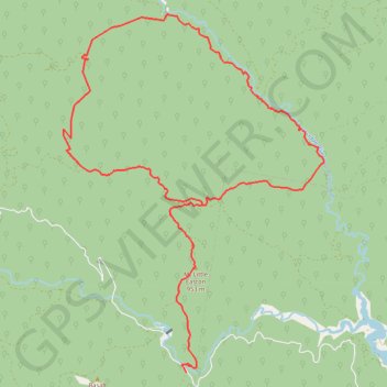
Upper Thomson Loop
Interactive trail map
Trail profile
- Distance: 32.6 Km
- Elevation gain: 1,595 m
- Maximum elevation: 1,113 m
- Elevation loss: 1,592 m
- Minimum elevation: 478 m
About this trail
Name: Upper Thomson Loop trail, distance, elevation, map, profile, GPS track
Start: Thomson - Jordan Road, Jericho, Shire of Baw Baw, Victoria, Australia (-37.71438 146.27523)
End: Thomson - Jordan Road, Jericho, Shire of Baw Baw, Victoria, Australia (-37.71530 146.27604)
Coordinates: -37.71530 146.24214 -37.63734 146.31374
Other hiking, mountain biking, running and outdoor activity trails
Click on a trail to view its statistics, map and profile.
Traralgon - Walhalla - Woods Point
Australia > Victoria > Traralgon
#Bike
Distance: 124.6 Km • Elevation gain: 4,258 m • Maximum elevation: 1,165 m
Moe - Woods Point
#Bike
Distance: 109.2 Km • Elevation gain: 3,295 m • Maximum elevation: 1,165 m