Make a donation
Gear up for your next adventure:
As an Amazon Associate, this site earns from qualifying purchases at no extra cost to you.
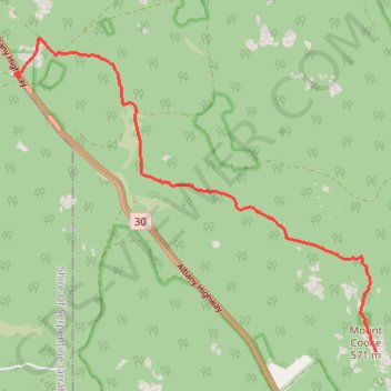
Sullivan Rock - Mount Cooke
- Distance: 9.7 Km
- Elevation gain: 367 m
- Maximum elevation: 563 m
- Elevation loss: 142 m
- Minimum elevation: 288 m
Interactive trail map
Make a donation
Gear up for your next adventure:
As an Amazon Associate, this site earns from qualifying purchases at no extra cost to you.
Trail profile
- Distance: 9.7 Km
- Elevation gain: 367 m
- Maximum elevation: 563 m
- Elevation loss: 142 m
- Minimum elevation: 288 m
Make a donation
Gear up for your next adventure:
As an Amazon Associate, this site earns from qualifying purchases at no extra cost to you.
About this trail
Name: Sullivan Rock - Mount Cooke trail, distance, elevation, map, profile, GPS track
End: Bibbulmun Track, Mount Cooke, Shire Of Wandering, Western Australia, Australia (-32.41837 116.30961)
Coordinates: -32.41837 116.25015 -32.37464 116.30961
Make a donation
Gear up for your next adventure:
As an Amazon Associate, this site earns from qualifying purchases at no extra cost to you.
Other hiking, mountain biking, running and outdoor activity trails
Click on a trail to view its statistics, map and profile.
Three Mountains Circuit: Mount Vincent - Mount Cuthbert - Mount Randall
Australia > Western Australia > Jarrahdale
Bibbulmun Track. Monadnocks Conservation Park. #Hiking #Loop #Monadnocks
Distance: 14.7 Km • Elevation gain: 422 m • Maximum elevation: 505 m