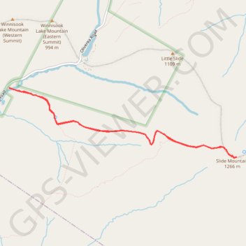
Slide Mountain
Hike from West Branch Neversink River to Slide Mountain via Phoenicia - East Branch Trail, Wittenberg - Cornell - Slide Trail and John Burroughs Monument in the Slide Mountain Wilderness and the Cattskill Park. #Hiking #Mountain #Nature #Forest #Wilderness #Park
- Distance: 8.6 Km
- Elevation gain: 526 m
- Maximum elevation: 1,263 m
- Elevation loss: 526 m
- Minimum elevation: 743 m
- Moving time: 2 h 23 m
- Moving speed: 3.6 Km/h
- Maximum speed: 5.5 Km/h
- Total time: 2 h 45 m
- Global speed: 3.1 Km/h
Interactive trail map
Trail profile
- Distance: 8.6 Km
- Elevation gain: 526 m
- Maximum elevation: 1,263 m
- Elevation loss: 526 m
- Minimum elevation: 743 m
- Moving time: 2 h 23 m
- Moving speed: 3.6 Km/h
- Maximum speed: 5.5 Km/h
- Total time: 2 h 45 m
- Global speed: 3.1 Km/h
About this trail
Name: Slide Mountain trail, distance, elevation, map, profile, GPS track
Coordinates: 41.99886 -74.42756 42.00862 -74.38511