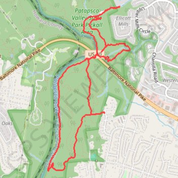
Patapsco Valley State Park Loop
Lopp hike through the Patapsco Valley State Park Rockhaven Area and Pickall Area via Rockhaven Avenue, Rockhaven Trail, Mill Race Trail, Patapsco River, Patapsco Thru Trail, Devil's Horns and Shale. #Hiking #Loop #Park #Forest #Nature #River
- Distance: 9.1 Km
- Elevation gain: 226 m
- Maximum elevation: 141 m
- Elevation loss: 227 m
- Minimum elevation: 52 m
- Moving time: 2 h 36 m
- Moving speed: 3.5 Km/h
- Maximum speed: 22.0 Km/h
- Total time: 2 h 51 m
- Global speed: 3.2 Km/h
Interactive trail map
Trail profile
- Distance: 9.1 Km
- Elevation gain: 226 m
- Maximum elevation: 141 m
- Elevation loss: 227 m
- Minimum elevation: 52 m
- Moving time: 2 h 36 m
- Moving speed: 3.5 Km/h
- Maximum speed: 22.0 Km/h
- Total time: 2 h 51 m
- Global speed: 3.2 Km/h
About this trail
Name: Patapsco Valley State Park Loop trail, distance, elevation, map, profile, GPS track
Coordinates: 39.27936 -76.78656 39.30128 -76.77244