
Wilson Peak and Kelly Lake Loop
Loop hike from Hunting Hollow Trailhead via Hunting Hollow Road, Lyman Willson Ridge Trail, Steer Ridge Road, Willson Camp, Wagon Road, Grizzly Gulch Trail, Tule Pond, Wasno Road, Wasno Pond, Crest Trail, Kelly Lake Trail, Kelly Lake, Dexter Trail, Willson Peak Trail, Willson Peak and Middle Steer Ridge Trail in the Henry W. Co State Park. #Hiking #Loop #Nature #Mountain #Lake #Forest #Park
- Distance: 26.5 Km
- Elevation gain: 1,364 m
- Maximum elevation: 803 m
- Elevation loss: 1,366 m
- Minimum elevation: 261 m
- Moving time: 7 h 48 m
- Moving speed: 3.4 Km/h
- Maximum speed: 5.3 Km/h
- Total time: 9 h 1 m
- Global speed: 2.9 Km/h
Interactive trail map
Trail profile
- Distance: 26.5 Km
- Elevation gain: 1,364 m
- Maximum elevation: 803 m
- Elevation loss: 1,366 m
- Minimum elevation: 261 m
- Moving time: 7 h 48 m
- Moving speed: 3.4 Km/h
- Maximum speed: 5.3 Km/h
- Total time: 9 h 1 m
- Global speed: 2.9 Km/h
About this trail
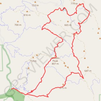
Name: Wilson Peak and Kelly Lake Loop trail, distance, elevation, map, profile, GPS track
Coordinates: 37.07123 -121.46664 37.12496 -121.41027