Thank you for supporting this site ❤️
Make a donation
Make a donation
Gear up for your next adventure:
As an Amazon Associate, this site earns from qualifying purchases at no extra cost to you.
Bits of Tipporogoree MTB Trails
Interactive trail map
Thank you for supporting this site ❤️
Make a donation
Make a donation
Gear up for your next adventure:
As an Amazon Associate, this site earns from qualifying purchases at no extra cost to you.
Trail profile
- Distance: 15.7 Km
- Elevation gain: 411 m
- Maximum elevation: 329 m
- Elevation loss: 412 m
- Minimum elevation: 28 m
- Moving time: 1 h 40 m
- Moving speed: 9.3 Km/h
- Maximum speed: 29.3 Km/h
- Total time: 2 h 3 m
- Global speed: 7.6 Km/h
Thank you for supporting this site ❤️
Make a donation
Make a donation
Gear up for your next adventure:
As an Amazon Associate, this site earns from qualifying purchases at no extra cost to you.
About this trail
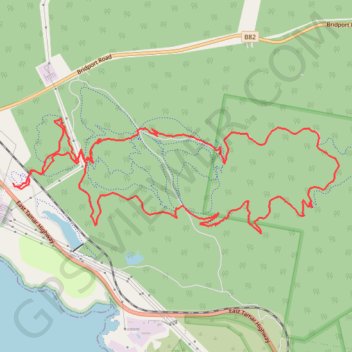
Name: Bits of Tipporogoree MTB Trails trail, distance, elevation, map, profile, GPS track
Start: Switchplate, Bell Bay, George Town, Tasmania, 7253, Australia (-41.12588 146.88770)
End: Switchplate, Bell Bay, George Town, Tasmania, 7253, Australia (-41.12557 146.88753)
Coordinates: -41.13065 146.88749 -41.11903 146.93108
Thank you for supporting this site ❤️
Make a donation
Make a donation
Gear up for your next adventure:
As an Amazon Associate, this site earns from qualifying purchases at no extra cost to you.