Thank you for supporting this site ❤️
Make a donation
Make a donation
Gear up for your next adventure:
As an Amazon Associate, this site earns from qualifying purchases at no extra cost to you.
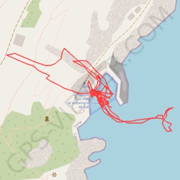
BANANA 21 SEPT 23
- Distance: 1.5 Km
- Elevation gain: 81 m
- Maximum elevation: 57 m
- Elevation loss: 78 m
- Minimum elevation: 0 m
- Moving time: 31 m 54 s
- Moving speed: 2.8 Km/h
- Maximum speed: 19.3 Km/h
- Total time: 2 h 34 m
- Global speed: 0.6 Km/h
Interactive trail map
Thank you for supporting this site ❤️
Make a donation
Make a donation
Gear up for your next adventure:
As an Amazon Associate, this site earns from qualifying purchases at no extra cost to you.
Trail profile
- Distance: 1.5 Km
- Elevation gain: 81 m
- Maximum elevation: 57 m
- Elevation loss: 78 m
- Minimum elevation: 0 m
- Moving time: 31 m 54 s
- Moving speed: 2.8 Km/h
- Maximum speed: 19.3 Km/h
- Total time: 2 h 34 m
- Global speed: 0.6 Km/h
Thank you for supporting this site ❤️
Make a donation
Make a donation
Gear up for your next adventure:
As an Amazon Associate, this site earns from qualifying purchases at no extra cost to you.
About this trail
Name: BANANA 21 SEPT 23 trail, distance, elevation, map, profile, GPS track
Start: D 81b, Delfineo, Calvi, Haute-Corse, Corsica, Metropolitan France, 20260, France (42.58010 8.72447)
Coordinates: 42.57982 8.72279 42.58080 8.72546
Thank you for supporting this site ❤️
Make a donation
Make a donation
Gear up for your next adventure:
As an Amazon Associate, this site earns from qualifying purchases at no extra cost to you.
Other hiking, mountain biking, running and outdoor activity trails
Click on a trail to view its statistics, map and profile.
1 LUCENA - MONTPELLIER
Distance: 2,964.4 Km • Elevation gain: 29,500 m • Maximum elevation: 1,048 m