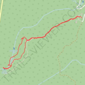
Hike to Bridal Vails and Champagne Falls
- Distance: 5.8 Km
- Elevation gain: 284 m
- Maximum elevation: 673 m
- Elevation loss: 288 m
- Minimum elevation: 469 m
- Moving time: 1 h 50 m
- Moving speed: 3.2 Km/h
- Maximum speed: 27.1 Km/h
- Total time: 2 h 14 m
- Global speed: 2.6 Km/h
Interactive trail map
Trail profile
- Distance: 5.8 Km
- Elevation gain: 284 m
- Maximum elevation: 673 m
- Elevation loss: 288 m
- Minimum elevation: 469 m
- Moving time: 1 h 50 m
- Moving speed: 3.2 Km/h
- Maximum speed: 27.1 Km/h
- Total time: 2 h 14 m
- Global speed: 2.6 Km/h
About this trail
Name: Hike to Bridal Vails and Champagne Falls trail, distance, elevation, map, profile, GPS track
Start: Lemonthyme Lodge, Dolcoath Road, Moina, Kentish, Tasmania, 7310, Australia (-41.52001 146.09946)
End: Dolcoath Road, Moina, Kentish, Tasmania, 7310, Australia (-41.52028 146.09990)
Coordinates: -41.53119 146.07736 -41.51986 146.09992