Thank you for supporting this site ❤️
Make a donation
Make a donation
Gear up for your next adventure:
As an Amazon Associate, this site earns from qualifying purchases at no extra cost to you.
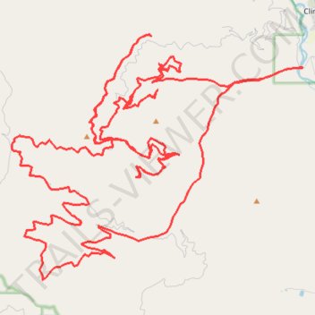
Swartz Creek loop
- Distance: 81.5 Km
- Elevation gain: 2,687 m
- Maximum elevation: 1,781 m
- Elevation loss: 2,687 m
- Minimum elevation: 1,060 m
- Moving time: 6 h 23 m
- Moving speed: 12.8 Km/h
- Maximum speed: 47.3 Km/h
- Total time: 7 h 4 m
- Global speed: 11.5 Km/h
Interactive trail map
Thank you for supporting this site ❤️
Make a donation
Make a donation
Gear up for your next adventure:
As an Amazon Associate, this site earns from qualifying purchases at no extra cost to you.
Trail profile
- Distance: 81.5 Km
- Elevation gain: 2,687 m
- Maximum elevation: 1,781 m
- Elevation loss: 2,687 m
- Minimum elevation: 1,060 m
- Moving time: 6 h 23 m
- Moving speed: 12.8 Km/h
- Maximum speed: 47.3 Km/h
- Total time: 7 h 4 m
- Global speed: 11.5 Km/h
Thank you for supporting this site ❤️
Make a donation
Make a donation
Gear up for your next adventure:
As an Amazon Associate, this site earns from qualifying purchases at no extra cost to you.
About this trail
Name: Swartz Creek loop trail, distance, elevation, map, profile, GPS track
Coordinates: 46.68638 -113.84876 46.76177 -113.71870
Thank you for supporting this site ❤️
Make a donation
Make a donation
Gear up for your next adventure:
As an Amazon Associate, this site earns from qualifying purchases at no extra cost to you.