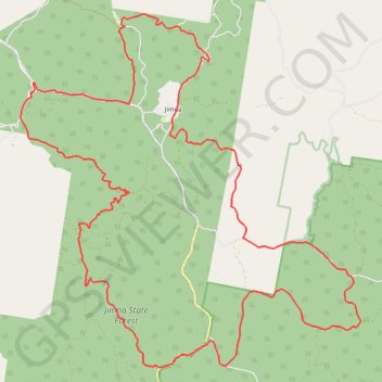
Jimna - Ponderosa Loop
Interactive trail map
Trail profile
- Distance: 48.8 Km
- Elevation gain: 1,385 m
- Maximum elevation: 682 m
- Elevation loss: 1,385 m
- Minimum elevation: 311 m
About this trail
Name: Jimna - Ponderosa Loop trail, distance, elevation, map, profile, GPS track
Start: Borgan Road, Jimna, Somerset Regional, Queensland, Australia (-26.66160 152.46534)
End: Borgan Road, Jimna, Somerset Regional, Queensland, Australia (-26.66158 152.46536)
Coordinates: -26.72796 152.42012 -26.63493 152.52063
Other hiking, mountain biking, running and outdoor activity trails
Click on a trail to view its statistics, map and profile.
Imbil Jimna Kenilworth loop
Australia > Queensland > Tewantin
Distance: 216.0 Km • Elevation gain: 3,884 m • Maximum elevation: 822 m