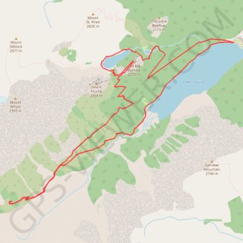
Lake Louise - Big Beehive - Plain of Six Glaciers
Interactive trail map
Trail profile
- Distance: 14.4 Km
- Elevation gain: 826 m
- Maximum elevation: 2,259 m
- Elevation loss: 826 m
- Minimum elevation: 1,738 m
About this trail
Name: Lake Louise - Big Beehive - Plain of Six Glaciers trail, distance, elevation, map, profile, GPS track
Start: Plain of Six Glaciers Trail, Improvement District No. 9, Alberta, Canada (51.41736 -116.21922)
End: Plain of Six Glaciers Trail, Improvement District No. 9, Alberta, Canada (51.41735 -116.21942)
Coordinates: 51.39296 -116.27361 51.41786 -116.21922
Topography: Improvement District No. 9 topographic map, elevation, terrain
Other hiking, mountain biking, running and outdoor activity trails
Click on a trail to view its statistics, map and profile.
Lake Louise and Lake Agnes Loop
Canada > Alberta > Improvement District No. 9
Distance: 11.3 Km • Elevation gain: 669 m • Maximum elevation: 2,254 m