Thank you for supporting this site ❤️
Make a donation
Make a donation
Gear up for your next adventure:
As an Amazon Associate, this site earns from qualifying purchases at no extra cost to you.
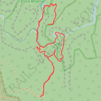
Lost City Walking Track
- Distance: 6.1 Km
- Elevation gain: 273 m
- Maximum elevation: 1,134 m
- Elevation loss: 273 m
- Minimum elevation: 996 m
- Moving time: 1 h 37 m
- Moving speed: 3.8 Km/h
- Maximum speed: 8.1 Km/h
- Total time: 1 h 54 m
- Global speed: 3.2 Km/h
Interactive trail map
Thank you for supporting this site ❤️
Make a donation
Make a donation
Gear up for your next adventure:
As an Amazon Associate, this site earns from qualifying purchases at no extra cost to you.
Trail profile
- Distance: 6.1 Km
- Elevation gain: 273 m
- Maximum elevation: 1,134 m
- Elevation loss: 273 m
- Minimum elevation: 996 m
- Moving time: 1 h 37 m
- Moving speed: 3.8 Km/h
- Maximum speed: 8.1 Km/h
- Total time: 1 h 54 m
- Global speed: 3.2 Km/h
Thank you for supporting this site ❤️
Make a donation
Make a donation
Gear up for your next adventure:
As an Amazon Associate, this site earns from qualifying purchases at no extra cost to you.
About this trail
Name: Lost City Walking Track trail, distance, elevation, map, profile, GPS track
Coordinates: -33.42748 150.17018 -33.41489 150.17467
Thank you for supporting this site ❤️
Make a donation
Make a donation
Gear up for your next adventure:
As an Amazon Associate, this site earns from qualifying purchases at no extra cost to you.