Crater Lake and Maroon Lake via Maroon-Snowmass Trail
The Crater Lake Trail in Colorado's Maroon Bells-Snowmass Wilderness offers hikers a moderately challenging journey through dense aspen and conifer forests, leading to the serene Crater Lake nestled beneath the towering Maroon Bells peaks. Along the path, adventurers traverse rocky terrains and alpine meadows, often catching glimpses of local wildlife such as marmots and pikas amidst the stunning backdrop of Pyramid Peak and Sievers Mountain. This trail provides an intimate experience of Colorado's pristine wilderness, rewarding visitors with breathtaking vistas and tranquil natural beauty. #Hiking #Lake #Mountain #Nature
- Distance: 5.7 Km
- Elevation gain: 207 m
- Maximum elevation: 3,104 m
- Elevation loss: 207 m
- Minimum elevation: 2,924 m
- Moving time: 1 h 56 m
- Moving speed: 3.0 Km/h
- Maximum speed: 5.3 Km/h
- Total time: 2 h 33 m
- Global speed: 2.2 Km/h
Interactive trail map
Trail profile
- Distance: 5.7 Km
- Elevation gain: 207 m
- Maximum elevation: 3,104 m
- Elevation loss: 207 m
- Minimum elevation: 2,924 m
- Moving time: 1 h 56 m
- Moving speed: 3.0 Km/h
- Maximum speed: 5.3 Km/h
- Total time: 2 h 33 m
- Global speed: 2.2 Km/h
About this trail
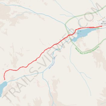
Name: Crater Lake and Maroon Lake via Maroon-Snowmass Trail trail, distance, elevation, map, profile, GPS track
Start: Maroon Lake Day Use Road, Pitkin County, Colorado, United States (39.09854 -106.94028)
End: Maroon Lake Day Use Road, Pitkin County, Colorado, United States (39.09858 -106.94035)
Coordinates: 39.08756 -106.96610 39.09858 -106.94028
Other hiking, mountain biking, running and outdoor activity trails
Click on a trail to view its statistics, map and profile.