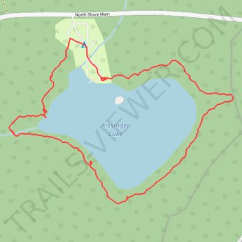
Kissinger Lake Loop Trail
- Distance: 2.5 Km
- Elevation gain: 53 m
- Maximum elevation: 217 m
- Elevation loss: 52 m
- Minimum elevation: 194 m
- Moving time: 55 m 48 s
- Moving speed: 2.7 Km/h
- Maximum speed: 4.6 Km/h
- Total time: 1 h 46 m
- Global speed: 1.4 Km/h
Interactive trail map
Trail profile
- Distance: 2.5 Km
- Elevation gain: 53 m
- Maximum elevation: 217 m
- Elevation loss: 52 m
- Minimum elevation: 194 m
- Moving time: 55 m 48 s
- Moving speed: 2.7 Km/h
- Maximum speed: 4.6 Km/h
- Total time: 1 h 46 m
- Global speed: 1.4 Km/h
About this trail
Name: Kissinger Lake Loop Trail trail, distance, elevation, map, profile, GPS track
Coordinates: 48.91685 -124.48528 48.92190 -124.47489
Topography: Area I (Youbou / Meade Creek) topographic map, elevation, terrain