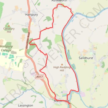
Maisemore to Ashleworth Loop
- Distance: 12.7 Km
- Elevation gain: 126 m
- Maximum elevation: 83 m
- Elevation loss: 128 m
- Minimum elevation: 8 m
- Moving time: 2 h 43 m
- Moving speed: 4.6 Km/h
- Maximum speed: 7.2 Km/h
- Total time: 3 h 38 m
- Global speed: 3.5 Km/h
Interactive trail map
Trail profile
- Distance: 12.7 Km
- Elevation gain: 126 m
- Maximum elevation: 83 m
- Elevation loss: 128 m
- Minimum elevation: 8 m
- Moving time: 2 h 43 m
- Moving speed: 4.6 Km/h
- Maximum speed: 7.2 Km/h
- Total time: 3 h 38 m
- Global speed: 3.5 Km/h
About this trail
Name: Maisemore to Ashleworth Loop trail, distance, elevation, map, profile, GPS track
Coordinates: 51.88836 -2.29300 51.92789 -2.26141
Other hiking, mountain biking, running and outdoor activity trails
Click on a trail to view its statistics, map and profile.
Dean2023-311
United Kingdom > England > Oxfordshire > Oxford
Distance: 310.3 Km • Elevation gain: 3,366 m • Maximum elevation: 290 m