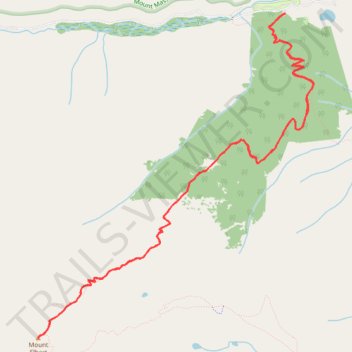
North Mount Elbert Trail in San Isabel National Forest
The North Mount Elbert Trail offers hikers a challenging yet rewarding journey through diverse landscapes, starting with dense forests of aspen and pine, and leading to the summit of Colorado's highest peak. As you ascend above the treeline, expansive views unfold, showcasing the Twin Lakes nestled amidst the valleys below. Upon reaching the summit, you're greeted with panoramic vistas of the Sawatch Range and neighboring 14,000-foot peaks, including the prominent Mount Massive to the north. #Hiking #Mountain #Forest #Nature
- Distance: 16.3 Km
- Elevation gain: 1,375 m
- Maximum elevation: 4,389 m
- Elevation loss: 1,375 m
- Minimum elevation: 3,068 m
- Moving time: 5 h 51 m
- Moving speed: 2.8 Km/h
- Maximum speed: 15.9 Km/h
- Total time: 7 h 41 m
- Global speed: 2.1 Km/h
Interactive trail map
Trail profile
- Distance: 16.3 Km
- Elevation gain: 1,375 m
- Maximum elevation: 4,389 m
- Elevation loss: 1,375 m
- Minimum elevation: 3,068 m
- Moving time: 5 h 51 m
- Moving speed: 2.8 Km/h
- Maximum speed: 15.9 Km/h
- Total time: 7 h 41 m
- Global speed: 2.1 Km/h
About this trail
Name: North Mount Elbert Trail in San Isabel National Forest trail, distance, elevation, map, profile, GPS track
Coordinates: 39.11762 -106.44539 39.15186 -106.40804
Other hiking, mountain biking, running and outdoor activity trails
Click on a trail to view its statistics, map and profile.
Continental Divide Trail (CDT)
United States > Colorado > Lake County
Hike on the Continental Divide National Scenic Trail between Halfmoon Creek and Copper Mountain through Mount Massive Wilderness, Holy Cross Wilderness, White River National Forest and Continental Divide National Monument in the Rocky Mountains. #Hiking #CDT #Mountain #Nature #River
Distance: 78.8 Km • Elevation gain: 2,807 m • Maximum elevation: 3,742 m