Thank you for supporting this site ❤️
Make a donation
Make a donation
Gear up for your next adventure:
As an Amazon Associate, this site earns from qualifying purchases at no extra cost to you.
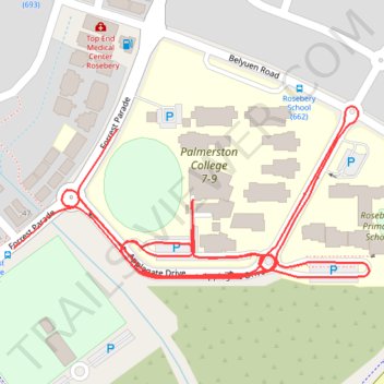
2025-05-04_16-55_Sun-PCMIDDLE
- Distance: 3.3 Km
- Elevation gain: 14 m
- Maximum elevation: 19 m
- Elevation loss: 14 m
- Minimum elevation: 10 m
- Moving time: 8 m 28 s
- Moving speed: 23.3 Km/h
- Maximum speed: 42.6 Km/h
- Total time: 8 m 28 s
- Global speed: 23.3 Km/h
Interactive trail map
Thank you for supporting this site ❤️
Make a donation
Make a donation
Gear up for your next adventure:
As an Amazon Associate, this site earns from qualifying purchases at no extra cost to you.
Trail profile
- Distance: 3.3 Km
- Elevation gain: 14 m
- Maximum elevation: 19 m
- Elevation loss: 14 m
- Minimum elevation: 10 m
- Moving time: 8 m 28 s
- Moving speed: 23.3 Km/h
- Maximum speed: 42.6 Km/h
- Total time: 8 m 28 s
- Global speed: 23.3 Km/h
Thank you for supporting this site ❤️
Make a donation
Make a donation
Gear up for your next adventure:
As an Amazon Associate, this site earns from qualifying purchases at no extra cost to you.
About this trail
Name: 2025-05-04_16-55_Sun-PCMIDDLE trail, distance, elevation, map, profile, GPS track
Coordinates: -12.51201 130.98872 -12.50963 130.99376
Thank you for supporting this site ❤️
Make a donation
Make a donation
Gear up for your next adventure:
As an Amazon Associate, this site earns from qualifying purchases at no extra cost to you.