Thank you for supporting this site ❤️
Make a donation
Make a donation
Gear up for your next adventure:
As an Amazon Associate, this site earns from qualifying purchases at no extra cost to you.
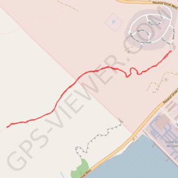
2024-08-08_10-35_Thu
- Distance: 3.9 Km
- Elevation gain: 292 m
- Maximum elevation: 344 m
- Elevation loss: 292 m
- Minimum elevation: 57 m
- Moving time: 1 h 14 m
- Moving speed: 3.1 Km/h
- Maximum speed: 6.6 Km/h
- Total time: 1 h 43 m
- Global speed: 2.3 Km/h
Interactive trail map
Thank you for supporting this site ❤️
Make a donation
Make a donation
Gear up for your next adventure:
As an Amazon Associate, this site earns from qualifying purchases at no extra cost to you.
Trail profile
- Distance: 3.9 Km
- Elevation gain: 292 m
- Maximum elevation: 344 m
- Elevation loss: 292 m
- Minimum elevation: 57 m
- Moving time: 1 h 14 m
- Moving speed: 3.1 Km/h
- Maximum speed: 6.6 Km/h
- Total time: 1 h 43 m
- Global speed: 2.3 Km/h
Thank you for supporting this site ❤️
Make a donation
Make a donation
Gear up for your next adventure:
As an Amazon Associate, this site earns from qualifying purchases at no extra cost to you.
About this trail
Name: 2024-08-08_10-35_Thu trail, distance, elevation, map, profile, GPS track
Start: Old Womens Mountain Trail, Kodiak Island, Alaska, 99619, United States (57.74460 -152.50701)
End: Old Womens Mountain Trail, Kodiak Island, Alaska, 99619, United States (57.74457 -152.50717)
Coordinates: 57.73843 -152.53179 57.74460 -152.50701
Thank you for supporting this site ❤️
Make a donation
Make a donation
Gear up for your next adventure:
As an Amazon Associate, this site earns from qualifying purchases at no extra cost to you.