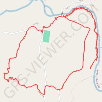
Lickeen walk
- Distance: 5.5 Km
- Elevation gain: 91 m
- Maximum elevation: 91 m
- Elevation loss: 91 m
- Minimum elevation: 18 m
- Moving time: 2 h 1 m
- Moving speed: 2.7 Km/h
- Maximum speed: 15.8 Km/h
- Total time: 3 h 5 s
- Global speed: 1.8 Km/h
Interactive trail map
Trail profile
- Distance: 5.5 Km
- Elevation gain: 91 m
- Maximum elevation: 91 m
- Elevation loss: 91 m
- Minimum elevation: 18 m
- Moving time: 2 h 1 m
- Moving speed: 2.7 Km/h
- Maximum speed: 15.8 Km/h
- Total time: 3 h 5 s
- Global speed: 1.8 Km/h
About this trail
Name: Lickeen walk trail, distance, elevation, map, profile, GPS track
Coordinates: 52.00723 -9.88920 52.01559 -9.87458