Red Mountain and Red Pond via Pacific Crest Trail and Commonwealth Basin Trail
The hike to Red Mountain and Red Pond in the Alpine Lakes Wilderness offers an engaging combination of lush forests, scenic meadows, and expansive mountain views. The route begins with a gradual climb through old-growth forests, followed by a steeper ascent as you approach the saddle between Red Mountain and Lundin Peak, where stunning panoramas unfold. Along the way, you'll encounter peaceful spots like Red Pond, surrounded by vibrant wildflowers and offering a serene atmosphere perfect for a break. #Hiking #Mountain #Forest #Nature #Lake
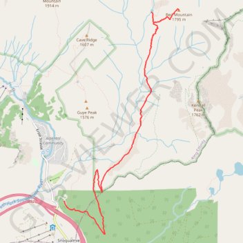
- Distance: 12.6 Km
- Elevation gain: 916 m
- Maximum elevation: 1,721 m
- Elevation loss: 981 m
- Minimum elevation: 925 m
Interactive trail map
Trail profile
- Distance: 12.6 Km
- Elevation gain: 916 m
- Maximum elevation: 1,721 m
- Elevation loss: 981 m
- Minimum elevation: 925 m
About this trail
Name: Red Mountain and Red Pond via Pacific Crest Trail and Commonwealth Basin Trail trail, distance, elevation, map, profile, GPS track
Coordinates: 47.42361 -121.41368 47.45634 -121.38912
Other hiking, mountain biking, running and outdoor activity trails
Click on a trail to view its statistics, map and profile.
Northern part of the Pacific Crest Trail (PCT)
United States > Oregon > Klamath County
Hike on the Pacific Crest National Scenic Trail from Crater Lake to Canada Border through Oregon and Washington along the Sierra Nevada and Cascade mountain ranges. #Hiking #Mountain #SierraNevada #Cascade #Nature #Forest #Park #PCT
Distance: 1,198.3 Km • Elevation gain: 44,308 m • Maximum elevation: 2,307 m
Old Commonwealth Trail to Kendall Katwalk
United States > Washington > King County > Snoqualmie Pass
Distance: 17.1 Km • Elevation gain: 947 m • Maximum elevation: 1,671 m