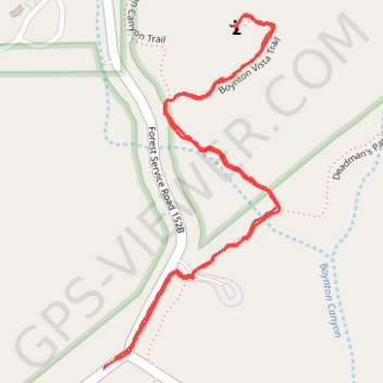
Boynton Vista Trail via Boynton Canyon Trail in Coconino National Forest
The Boynton Vista Trail in Sedona, Arizona, offers a memorable hiking experience characterized by striking red rock formations and serene desert vistas. Along the way, hikers can admire unique sandstone spires such as the Kachina Woman and Warrior Rock, landmarks steeped in natural beauty and cultural significance, while the surrounding vistas showcase sweeping views of nearby canyons and mesas, such as Deadman's Pass and Mescal Mountain. This trail also leads to one of Sedona's famed energy vortexes, where visitors often pause to meditate, reflect, or simply enjoy the tranquil views of the surrounding box canyon and lush juniper trees, making it a blend of natural wonder and spiritual allure. #Hiking #Forest #Rock #Nature
- Distance: 2.3 Km
- Elevation gain: 58 m
- Maximum elevation: 1,425 m
- Elevation loss: 58 m
- Minimum elevation: 1,378 m
- Moving time: 39 m 16 s
- Moving speed: 3.5 Km/h
- Maximum speed: 6.1 Km/h
- Total time: 1 h 2 m
- Global speed: 2.2 Km/h
Interactive trail map
Trail profile
- Distance: 2.3 Km
- Elevation gain: 58 m
- Maximum elevation: 1,425 m
- Elevation loss: 58 m
- Minimum elevation: 1,378 m
- Moving time: 39 m 16 s
- Moving speed: 3.5 Km/h
- Maximum speed: 6.1 Km/h
- Total time: 1 h 2 m
- Global speed: 2.2 Km/h
About this trail
Name: Boynton Vista Trail via Boynton Canyon Trail in Coconino National Forest trail, distance, elevation, map, profile, GPS track
Start: Boynton Pass Road, Yavapai County, Arizona, 86340, United States (34.90603 -111.85092)
End: Boynton Pass Road, Yavapai County, Arizona, 86340, United States (34.90620 -111.85068)
Coordinates: 34.90603 -111.85092 34.91196 -111.84732
Other hiking, mountain biking, running and outdoor activity trails
Click on a trail to view its statistics, map and profile.
Boynton Canyon Trail via Boynton Vista and Boynton Subway in Red Rock-Secret Mountain Wilderness
United States > Arizona > Yavapai County
The Boynton Canyon Trail offers a peaceful journey through shaded forests, towering red rock formations, and sweeping views of the canyon floor. While the trail itself is easy to follow, it features a bit of a climb toward the end, making it a nice mix of challenge and relaxation. For an extra treat, take the…
Distance: 12.8 Km • Elevation gain: 480 m • Maximum elevation: 1,595 m