Thank you for supporting this site ❤️
Make a donation
Make a donation
Gear up for your next adventure:
As an Amazon Associate, this site earns from qualifying purchases at no extra cost to you.
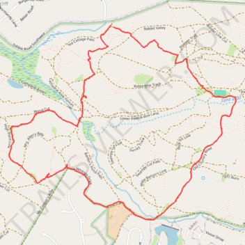
Loop walk in Hitchcock woods
- Distance: 7.4 Km
- Elevation gain: 117 m
- Maximum elevation: 130 m
- Elevation loss: 116 m
- Minimum elevation: 89 m
- Moving time: 1 h 35 m
- Moving speed: 4.6 Km/h
- Maximum speed: 21.4 Km/h
- Total time: 1 h 39 m
- Global speed: 4.4 Km/h
Interactive trail map
Thank you for supporting this site ❤️
Make a donation
Make a donation
Gear up for your next adventure:
As an Amazon Associate, this site earns from qualifying purchases at no extra cost to you.
Trail profile
- Distance: 7.4 Km
- Elevation gain: 117 m
- Maximum elevation: 130 m
- Elevation loss: 116 m
- Minimum elevation: 89 m
- Moving time: 1 h 35 m
- Moving speed: 4.6 Km/h
- Maximum speed: 21.4 Km/h
- Total time: 1 h 39 m
- Global speed: 4.4 Km/h
Thank you for supporting this site ❤️
Make a donation
Make a donation
Gear up for your next adventure:
As an Amazon Associate, this site earns from qualifying purchases at no extra cost to you.
About this trail
Name: Loop walk in Hitchcock woods trail, distance, elevation, map, profile, GPS track
Start: Tea Cottage Path, Westcliff, Aiken County, South Carolina, 29801, United States (33.55619 -81.75311)
End: Tea Cottage Path, Westcliff, Aiken County, South Carolina, 29801, United States (33.55604 -81.75289)
Coordinates: 33.54061 -81.76291 33.55619 -81.74116
Thank you for supporting this site ❤️
Make a donation
Make a donation
Gear up for your next adventure:
As an Amazon Associate, this site earns from qualifying purchases at no extra cost to you.