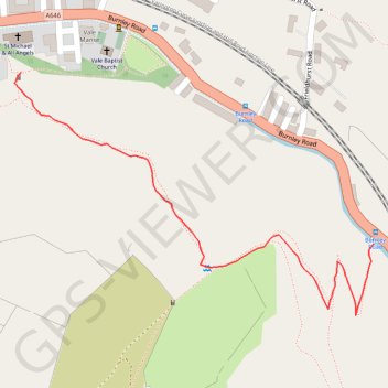
Vale to Barewise Bridge
#Todmorden #Calderdale #Hiking #Nature #River
- Distance: 0.8 Km
- Elevation gain: 72 m
- Maximum elevation: 267 m
- Elevation loss: 87 m
- Minimum elevation: 179 m
- Moving time: 22 m 15 s
- Moving speed: 2.2 Km/h
- Maximum speed: 4.2 Km/h
- Total time: 32 m 13 s
- Global speed: 1.6 Km/h
Interactive trail map
Trail profile
- Distance: 0.8 Km
- Elevation gain: 72 m
- Maximum elevation: 267 m
- Elevation loss: 87 m
- Minimum elevation: 179 m
- Moving time: 22 m 15 s
- Moving speed: 2.2 Km/h
- Maximum speed: 4.2 Km/h
- Total time: 32 m 13 s
- Global speed: 1.6 Km/h
About this trail
Name: Vale to Barewise Bridge trail, distance, elevation, map, profile, GPS track
Coordinates: 53.72908 -2.13732 53.73177 -2.13060