Thank you for supporting this site ❤️
Make a donation
Make a donation
Gear up for your next adventure:
As an Amazon Associate, this site earns from qualifying purchases at no extra cost to you.
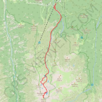
Musala peak, the highest of Bulgaria (and the whole Balkan)
- Distance: 25.5 Km
- Elevation gain: 1,558 m
- Maximum elevation: 2,921 m
- Elevation loss: 1,558 m
- Minimum elevation: 1,410 m
Interactive trail map
Thank you for supporting this site ❤️
Make a donation
Make a donation
Gear up for your next adventure:
As an Amazon Associate, this site earns from qualifying purchases at no extra cost to you.
Trail profile
- Distance: 25.5 Km
- Elevation gain: 1,558 m
- Maximum elevation: 2,921 m
- Elevation loss: 1,558 m
- Minimum elevation: 1,410 m
Thank you for supporting this site ❤️
Make a donation
Make a donation
Gear up for your next adventure:
As an Amazon Associate, this site earns from qualifying purchases at no extra cost to you.
About this trail
Name: Musala peak, the highest of Bulgaria (and the whole Balkan) trail, distance, elevation, map, profile, GPS track
Start: SFO1570, Borovets, Samokov, Sofia, 2010, Bulgaria (42.25689 23.59721)
End: SFO1570, Borovets, Samokov, Sofia, 2010, Bulgaria (42.25691 23.59718)
Coordinates: 42.17874 23.58169 42.25868 23.60595
Thank you for supporting this site ❤️
Make a donation
Make a donation
Gear up for your next adventure:
As an Amazon Associate, this site earns from qualifying purchases at no extra cost to you.