
Seneca Rocks Trail in Monongahela National Forest
Hiking the Seneca Rocks Trail is a delightful journey through the heart of West Virginia's breathtaking landscapes. As you ascend, the impressive rock formations tower above, providing stunning views of the lush valleys and distant mountain ridges, while the well-maintained path features gentle switchbacks and wooden stairs that make the climb enjoyable. The summit offers a mesmerizing panorama, perfect for capturing memorable photos and soaking in the natural beauty of the surrounding area. #Hiking #Mountain #Rock#Forest #Nature
- Distance: 5.0 Km
- Elevation gain: 253 m
- Maximum elevation: 703 m
- Elevation loss: 253 m
- Minimum elevation: 465 m
- Moving time: 1 h 17 m
- Moving speed: 3.9 Km/h
- Maximum speed: 6.8 Km/h
- Total time: 2 h 6 s
- Global speed: 2.5 Km/h
Interactive trail map
Trail profile
- Distance: 5.0 Km
- Elevation gain: 253 m
- Maximum elevation: 703 m
- Elevation loss: 253 m
- Minimum elevation: 465 m
- Moving time: 1 h 17 m
- Moving speed: 3.9 Km/h
- Maximum speed: 6.8 Km/h
- Total time: 2 h 6 s
- Global speed: 2.5 Km/h
About this trail
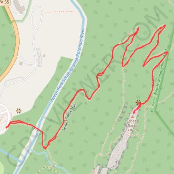
Name: Seneca Rocks Trail in Monongahela National Forest trail, distance, elevation, map, profile, GPS track
Start: Seneca Rocks, Pendleton County, West Virginia, 26884, United States (38.83533 -79.37269)
End: Seneca Rocks, Pendleton County, West Virginia, 26884, United States (38.83534 -79.37267)
Coordinates: 38.83436 -79.37269 38.83977 -79.36365