Pacific Crest Trail (PCT) through San Bernardino Forest and Santa Rosa and San Jacinto Mountains
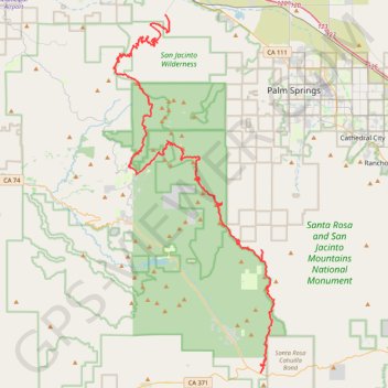
Hike from Bull Canyon Parking to Snow Creek along the Pacific Crest National Scenic Trail via Lion Peak, Pyramid Peak, Cedar Spring, Palm View Peak, Fobes Saddle, Spitler Peak, Apache Peak, Apache Spring, Antsell Rock, South Peak, Red Tahquitz, Tahquitz Meadow, Powderbox Spring, Middle Spring, Jolley Spring, Idylwild, Deer Springs Trail and Castle Rocks in the San Bernardino National Forest and the Santa Rosa and San Jacinto Mountains National Monument. #Hiking #PCT #Nature #Mountain #Forest
- Distance: 95.0 Km
- Elevation gain: 3,982 m
- Maximum elevation: 2,737 m
- Elevation loss: 5,104 m
- Minimum elevation: 376 m
- Moving time: 1 d 5 h
- Moving speed: 3.2 Km/h
- Maximum speed: 5.6 Km/h
- Total time: 5 d 1 m
- Global speed: 0.8 Km/h
Interactive trail map
Trail profile
- Distance: 95.0 Km
- Elevation gain: 3,982 m
- Maximum elevation: 2,737 m
- Elevation loss: 5,104 m
- Minimum elevation: 376 m
- Moving time: 1 d 5 h
- Moving speed: 3.2 Km/h
- Maximum speed: 5.6 Km/h
- Total time: 5 d 1 m
- Global speed: 0.8 Km/h
About this trail
Name: Pacific Crest Trail (PCT) through San Bernardino Forest and Santa Rosa and San Jacinto Mountains trail, distance, elevation, map, profile, GPS track
Start: Bull Canyon Parking, Riverside County, California, United States (33.56322 -116.57671)
End: Snow Creek Road, Snow Creek, Riverside County, California, United States (33.89376 -116.68290)
Coordinates: 33.56322 -116.74010 33.89376 -116.56198
Other hiking, mountain biking, running and outdoor activity trails
Click on a trail to view its statistics, map and profile.
Ernie Maxwell Scenic Trail
United States > California > Riverside County > Idyllwild
Starting from the Idyllwild side near Tahquitz View Drive, the Ernie Maxwell Scenic Trail climbs gently through shaded pine, oak, cedar and manzanita forest on the lower slopes of the San Jacinto Mountains. The route passes granite boulders and seasonal drainages before opening occasional views across…
Distance: 3.8 Km • Elevation gain: 285 m • Maximum elevation: 1,966 m
Tahquitz Peak via South Ridge Trail in San Jacinto Wilderness
United States > California > Riverside County
The South Ridge Trail to Tahquitz Peak offers hikers an invigorating ascent through a dense pine and oak forest, with expansive views of Idyllwild, Suicide Rock, and Lily Rock emerging as you climb. As you gain elevation, the trail opens up to breathtaking vistas of the San Jacinto Mountains, offering glimpses…
Distance: 10.6 Km • Elevation gain: 698 m • Maximum elevation: 2,667 m
San Jacinto Peak via Palm Springs Aerial Tramway, Round Valley Trail and Peak Trail
United States > California > Riverside County
The hike to San Jacinto Peak is a stunning journey through diverse landscapes, starting with a steep ascent that transitions into tranquil alpine meadows. As you make your way through Round Valley and past Wellman Divide, the trail gradually opens to reveal expansive views of the Coachella Valley and…
Distance: 16.9 Km • Elevation gain: 785 m • Maximum elevation: 3,280 m
Suicide Rock
United States > California > Riverside County > Idyllwild
Hike to Suicide Rock by the Deer Springs Trail and the Suicide Rock Trail in the San Bernardino National Forest and the Mount San Jacinto State Wilderness. #Hiking #Mountain #Nature #Forest #Wilderness
Distance: 5.4 Km • Elevation gain: 568 m • Maximum elevation: 2,265 m
Cactus to Clouds
United States > California > Riverside County > Palm Springs
Hike from Palm Springs to San Jacinto Peak by the Skyline Trail, the Grubbs Notch, the Round Valley Trail, the Wellman Divide and the Peak Trail in the Santa Rosa and San Jacinto Mountains National Monument. #Hiking #Mountain #Nature #Forest #Park
Distance: 31.6 Km • Elevation gain: 3,298 m • Maximum elevation: 3,280 m
Mount Jacinto Loop
United States > California > Riverside County > Idyllwild
Loop Hike to Mount Jacinto via Deer Springs Trail, Pacific Crest Trail (PCT), Peak Trail and Wellman's Cienaga Trail in the San Bernardino National Forest and the Mount San Jacinto State Park. #Hiking #Loop #Mountain #Nature #Forest #Park #PCT
Distance: 28.0 Km • Elevation gain: 1,646 m • Maximum elevation: 3,279 m
Suicide Rock
United States > California > Riverside County > Idyllwild
Hike from Idyllwild Nature Center to Suicide Rock via Deer Springs Trail and Suicide Rock Trail in the San Bernardino National Forest and the Mount San Jacinto State Wilderness. #Hiking #Mountain #Nature #Forest #Wilderness
Distance: 12.0 Km • Elevation gain: 638 m • Maximum elevation: 2,262 m
Willow Creek Trail to Caramba Overlook via Hidden Lake and Round Valley Loop
United States > California > Riverside County
Distance: 17.7 Km • Elevation gain: 886 m • Maximum elevation: 2,675 m
PCT from Black Mountain Road to Strawberry Junction
United States > California > Riverside County
Pacific Crest National Scenic Trail (PCT)
Distance: 23.9 Km • Elevation gain: 1,098 m • Maximum elevation: 2,740 m
PCT CA-B Fobes Ranch Road to Cedar Spring Junction and back
United States > California > Riverside County
Distance: 18.5 Km • Elevation gain: 809 m • Maximum elevation: 2,170 m
Lookout Mountain (San Diego County)
United States > California > Riverside County
Distance: 6.7 Km • Elevation gain: 337 m • Maximum elevation: 1,698 m
Ernie Maxwell Trail
United States > California > Riverside County > Idyllwild
Riverside County Hiking
Distance: 7.9 Km • Elevation gain: 354 m • Maximum elevation: 1,965 m
Ramona Trail
United States > California > Riverside County
Riverside County Hiking
Distance: 5.3 Km • Elevation gain: 251 m • Maximum elevation: 1,602 m
Cowbell trail
United States > California > Riverside County > Mountain Center
Distance: 6.3 Km • Elevation gain: 364 m • Maximum elevation: 1,760 m