Make a donation
Gear up for your next adventure:
As an Amazon Associate, this site earns from qualifying purchases at no extra cost to you.
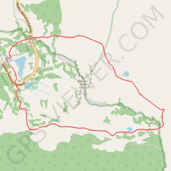
Naches Peak Loop
Starting from the Tipsoo Lake area, the loop climbs toward Chinook Pass, crosses the highway footbridge, and joins the Pacific Crest Trail as it skirts the north and east side of Naches Peak through subalpine forest, open slopes, and small mountain ponds.
The route then bends around the quieter eastern shoulder of the peak, with broad alpine views toward Dewey Lake country before meeting the Naches Peak Loop Trail and turning back across flowered meadows, tarns, and exposed viewpoints where Mount Rainier becomes the main backdrop.
The final stretch follows the west side of Naches Peak toward the Tipsoo Lake basin, returning through meadow-fringed water, wetland edges, and forest patches to complete one of Mount Rainier’s classic high-country loops.
#Hiking #Loop #Forest #Mountain #Nature #Lake #Meadow #Viewpoint
- Distance: 5.4 Km
- Elevation gain: 205 m
- Maximum elevation: 1,793 m
- Elevation loss: 205 m
- Minimum elevation: 1,616 m
Interactive trail map
Make a donation
Gear up for your next adventure:
As an Amazon Associate, this site earns from qualifying purchases at no extra cost to you.
Trail profile
- Distance: 5.4 Km
- Elevation gain: 205 m
- Maximum elevation: 1,793 m
- Elevation loss: 205 m
- Minimum elevation: 1,616 m
Make a donation
Gear up for your next adventure:
As an Amazon Associate, this site earns from qualifying purchases at no extra cost to you.
About this trail
Name: Naches Peak Loop trail, distance, elevation, map, profile, GPS track
Coordinates: 46.86164 -121.51945 46.87221 -121.49497
Make a donation
Gear up for your next adventure:
As an Amazon Associate, this site earns from qualifying purchases at no extra cost to you.
Other hiking, mountain biking, running and outdoor activity trails
Click on a trail to view its statistics, map and profile.
Northern part of the Pacific Crest Trail (PCT)
United States > Oregon > Klamath County
Hike on the Pacific Crest National Scenic Trail from Crater Lake to Canada Border through Oregon and Washington along the Sierra Nevada and Cascade mountain ranges. #Hiking #Mountain #SierraNevada #Cascade #Nature #Forest #Park #PCT
Distance: 1,198.3 Km • Elevation gain: 44,308 m • Maximum elevation: 2,307 m