Thank you for supporting this site ❤️
Make a donation
Make a donation
Gear up for your next adventure:
As an Amazon Associate, this site earns from qualifying purchases at no extra cost to you.
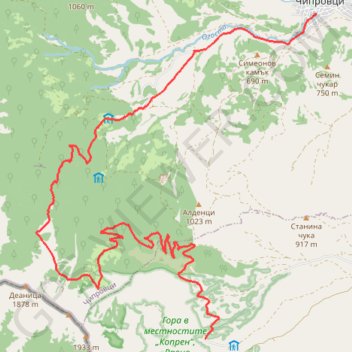
Kopren-Chiprovtsi
- Distance: 19.4 Km
- Elevation gain: 728 m
- Maximum elevation: 1,564 m
- Elevation loss: 1,185 m
- Minimum elevation: 498 m
- Moving time: 2 h 30 m
- Moving speed: 7.7 Km/h
- Maximum speed: 54.9 Km/h
- Total time: 4 h 16 m
- Global speed: 4.5 Km/h
Interactive trail map
Thank you for supporting this site ❤️
Make a donation
Make a donation
Gear up for your next adventure:
As an Amazon Associate, this site earns from qualifying purchases at no extra cost to you.
Trail profile
- Distance: 19.4 Km
- Elevation gain: 728 m
- Maximum elevation: 1,564 m
- Elevation loss: 1,185 m
- Minimum elevation: 498 m
- Moving time: 2 h 30 m
- Moving speed: 7.7 Km/h
- Maximum speed: 54.9 Km/h
- Total time: 4 h 16 m
- Global speed: 4.5 Km/h
Thank you for supporting this site ❤️
Make a donation
Make a donation
Gear up for your next adventure:
As an Amazon Associate, this site earns from qualifying purchases at no extra cost to you.
About this trail
Name: Kopren-Chiprovtsi trail, distance, elevation, map, profile, GPS track
Start: Kopilovtsi, Georgi Damianovo, Montana, 3467, Bulgaria (43.32820 22.85471)
End: Павлето, Chiprovtsi, Montana, Bulgaria (43.38221 22.87985)
Coordinates: 43.32820 22.81607 43.38221 22.87985
Thank you for supporting this site ❤️
Make a donation
Make a donation
Gear up for your next adventure:
As an Amazon Associate, this site earns from qualifying purchases at no extra cost to you.