Make a donation
Gear up for your next adventure:
As an Amazon Associate, this site earns from qualifying purchases at no extra cost to you.
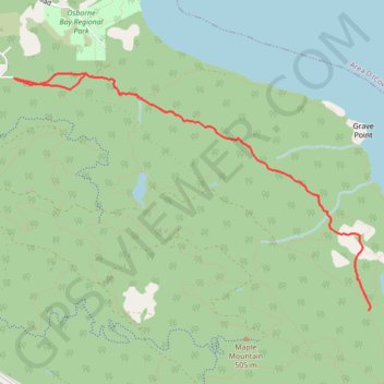
Osborne Bay Regional Park - Blue Trail
North Cowichan Municipal Forest Reserve. #Hiking #Running #OsborneBay #NorthCowichan
- Distance: 8.8 Km
- Elevation gain: 433 m
- Maximum elevation: 246 m
- Elevation loss: 433 m
- Minimum elevation: 83 m
Interactive trail map
Make a donation
Gear up for your next adventure:
As an Amazon Associate, this site earns from qualifying purchases at no extra cost to you.
Trail profile
- Distance: 8.8 Km
- Elevation gain: 433 m
- Maximum elevation: 246 m
- Elevation loss: 433 m
- Minimum elevation: 83 m
Make a donation
Gear up for your next adventure:
As an Amazon Associate, this site earns from qualifying purchases at no extra cost to you.
About this trail
Name: Osborne Bay Regional Park - Blue Trail trail, distance, elevation, map, profile, GPS track
Coordinates: 48.83418 -123.63215 48.85195 -123.59170
Topography: Cowichan Valley Regional District topographic map, elevation, terrain
Make a donation
Gear up for your next adventure:
As an Amazon Associate, this site earns from qualifying purchases at no extra cost to you.
Other hiking, mountain biking, running and outdoor activity trails
Click on a trail to view its statistics, map and profile.
BBF loop to the Skydeck in Nanaimo
Canada > British Columbia > Cowichan Valley Regional District > Area A (Mill Bay / Malahat) > Mill Bay
BBF loop to the Skydeck
Distance: 323.5 Km • Elevation gain: 6,222 m • Maximum elevation: 706 m