Hartshorne Woods Park & Huber Woods County Park
- Distance: 41.4 Km
- Elevation gain: 825 m
- Maximum elevation: 79 m
- Elevation loss: 825 m
- Minimum elevation: 0 m
- Moving time: 3 h 43 m
- Moving speed: 11.1 Km/h
- Maximum speed: 31.8 Km/h
- Total time: 4 h 29 m
- Global speed: 9.2 Km/h
Interactive trail map
Trail profile
- Distance: 41.4 Km
- Elevation gain: 825 m
- Maximum elevation: 79 m
- Elevation loss: 825 m
- Minimum elevation: 0 m
- Moving time: 3 h 43 m
- Moving speed: 11.1 Km/h
- Maximum speed: 31.8 Km/h
- Total time: 4 h 29 m
- Global speed: 9.2 Km/h
About this trail
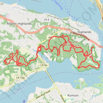
Name: Hartshorne Woods Park & Huber Woods County Park trail, distance, elevation, map, profile, GPS track
Coordinates: 40.38550 -74.04426 40.40227 -73.98182
Other hiking, mountain biking, running and outdoor activity trails
Click on a trail to view its statistics, map and profile.
Atlantic highlands
United States > New Jersey > Monmouth County > Middletown Township > Stone Church
A Perfect Summer Day
Distance: 57.2 Km • Elevation gain: 726 m • Maximum elevation: 79 m
Hartshorne Huber Beach
United States > New Jersey > Monmouth County > Middletown Township > Stone Church
Hartshorne Woods Park
Distance: 61.3 Km • Elevation gain: 1,250 m • Maximum elevation: 79 m