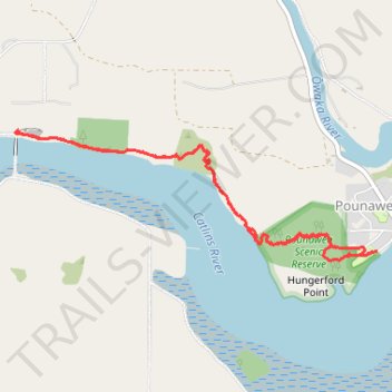
Pounawea Bush Walk via Hinahina Track
- Distance: 6.5 Km
- Elevation gain: 100 m
- Maximum elevation: 32 m
- Elevation loss: 100 m
- Minimum elevation: 1 m
- Moving time: 1 h 24 m
- Moving speed: 4.6 Km/h
- Maximum speed: 7.3 Km/h
- Total time: 1 h 46 m
- Global speed: 3.7 Km/h
Interactive trail map
Trail profile
- Distance: 6.5 Km
- Elevation gain: 100 m
- Maximum elevation: 32 m
- Elevation loss: 100 m
- Minimum elevation: 1 m
- Moving time: 1 h 24 m
- Moving speed: 4.6 Km/h
- Maximum speed: 7.3 Km/h
- Total time: 1 h 46 m
- Global speed: 3.7 Km/h
About this trail
Name: Pounawea Bush Walk via Hinahina Track trail, distance, elevation, map, profile, GPS track
Start: 1, Park Lane, Pounawea, Clutha District, Otago, 9535, New Zealand (-46.47588 169.69387)
End: Park Lane, Pounawea, Clutha District, Otago, 9535, New Zealand (-46.47589 169.69377)
Coordinates: -46.47641 169.66372 -46.46899 169.69387
Other hiking, mountain biking, running and outdoor activity trails
Click on a trail to view its statistics, map and profile.