Make a donation
Gear up for your next adventure:
As an Amazon Associate, this site earns from qualifying purchases at no extra cost to you.
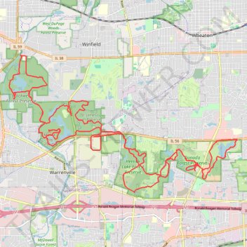
Gravel bike loop
Danada Forest Preserve, Rice Lake, Herrick Lake Forest Preserve, St. James Farm Preserve, Silver Lake, Mount Hoy, Blackwell Forest Preserve, McKee Marsh.
- Distance: 47.0 Km
- Elevation gain: 261 m
- Maximum elevation: 249 m
- Elevation loss: 261 m
- Minimum elevation: 212 m
- Moving time: 2 h 17 m
- Moving speed: 20.5 Km/h
- Maximum speed: 45.7 Km/h
- Total time: 2 h 24 m
- Global speed: 19.5 Km/h
Interactive trail map
Make a donation
Gear up for your next adventure:
As an Amazon Associate, this site earns from qualifying purchases at no extra cost to you.
Trail profile
- Distance: 47.0 Km
- Elevation gain: 261 m
- Maximum elevation: 249 m
- Elevation loss: 261 m
- Minimum elevation: 212 m
- Moving time: 2 h 17 m
- Moving speed: 20.5 Km/h
- Maximum speed: 45.7 Km/h
- Total time: 2 h 24 m
- Global speed: 19.5 Km/h
Make a donation
Gear up for your next adventure:
As an Amazon Associate, this site earns from qualifying purchases at no extra cost to you.
About this trail
Name: Gravel bike loop trail, distance, elevation, map, profile, GPS track
Start: Frank H. Bellinger Parkway, DuPage County, Illinois, 60189, United States (41.81845 -88.11321)
End: Frank H. Bellinger Parkway, DuPage County, Illinois, 60189, United States (41.81843 -88.11319)
Coordinates: 41.81102 -88.19838 41.85805 -88.09376
Make a donation
Gear up for your next adventure:
As an Amazon Associate, this site earns from qualifying purchases at no extra cost to you.