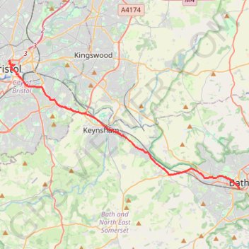
2024-03-30_10-35_Sat
- Distance: 21.4 Km
- Elevation gain: 200 m
- Maximum elevation: 59 m
- Elevation loss: 202 m
- Minimum elevation: 10 m
Interactive trail map
Trail profile
- Distance: 21.4 Km
- Elevation gain: 200 m
- Maximum elevation: 59 m
- Elevation loss: 202 m
- Minimum elevation: 10 m
About this trail
Name: 2024-03-30_10-35_Sat trail, distance, elevation, map, profile, GPS track
Coordinates: 51.37767 -2.59388 51.45914 -2.35878
Other hiking, mountain biking, running and outdoor activity trails
Click on a trail to view its statistics, map and profile.
Saltford Water Recycling Bridge
United Kingdom > England > Bath and North East Somerset > Kelston
Saltford, Water, Recycling, Bridge
Distance: 4.2 Km • Elevation gain: 30 m • Maximum elevation: 30 m
Newbridge P&R paths
United Kingdom > England > Bath and North East Somerset > Bath
Distance: 3.5 Km • Elevation gain: 59 m • Maximum elevation: 58 m
Dean2023-311
United Kingdom > England > Oxfordshire > Oxford
Distance: 310.3 Km • Elevation gain: 3,366 m • Maximum elevation: 290 m
Bristol
United Kingdom > England > North Somerset > Leigh Woods
Distance: 23.7 Km • Elevation gain: 392 m • Maximum elevation: 129 m