Make a donation
Gear up for your next adventure:
As an Amazon Associate, this site earns from qualifying purchases at no extra cost to you.
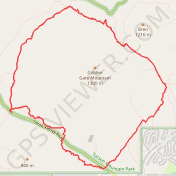
Kinney Trail and others circling Golden Gate Mountain, Tucson
Loop hike around Golden Gate Mountain via Kinney Trail, Tucson Estates Trail, Coyote Trail, Yetman Trail and Golden Gate Trail in the Tucson Mountain Park. #Hiking #Loop #Mountain #Nature
- Distance: 10.5 Km
- Elevation gain: 218 m
- Maximum elevation: 976 m
- Elevation loss: 219 m
- Minimum elevation: 794 m
- Moving time: 2 h 30 m
- Moving speed: 4.2 Km/h
- Maximum speed: 31.5 Km/h
- Total time: 2 h 45 m
- Global speed: 3.8 Km/h
Interactive trail map
Make a donation
Gear up for your next adventure:
As an Amazon Associate, this site earns from qualifying purchases at no extra cost to you.
Trail profile
- Distance: 10.5 Km
- Elevation gain: 218 m
- Maximum elevation: 976 m
- Elevation loss: 219 m
- Minimum elevation: 794 m
- Moving time: 2 h 30 m
- Moving speed: 4.2 Km/h
- Maximum speed: 31.5 Km/h
- Total time: 2 h 45 m
- Global speed: 3.8 Km/h
Make a donation
Gear up for your next adventure:
As an Amazon Associate, this site earns from qualifying purchases at no extra cost to you.
About this trail
Name: Kinney Trail and others circling Golden Gate Mountain, Tucson trail, distance, elevation, map, profile, GPS track
Start: K9, South Kinney Road, Pima County, Arizona, 85735, United States (32.20197 -111.12206)
End: 253, South Kinney Road, Pima County, Arizona, 85735, United States (32.20160 -111.12178)
Coordinates: 32.19241 -111.12225 32.21879 -111.09222
Make a donation
Gear up for your next adventure:
As an Amazon Associate, this site earns from qualifying purchases at no extra cost to you.