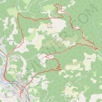
Track
- Distance: 20.1 Km
- Elevation gain: 998 m
- Maximum elevation: 1,167 m
- Elevation loss: 999 m
- Minimum elevation: 389 m
- Moving time: 4 h 18 m
- Moving speed: 4.6 Km/h
- Maximum speed: 18.0 Km/h
- Total time: 4 h 52 m
- Global speed: 4.1 Km/h
Interactive trail map
Trail profile
- Distance: 20.1 Km
- Elevation gain: 998 m
- Maximum elevation: 1,167 m
- Elevation loss: 999 m
- Minimum elevation: 389 m
- Moving time: 4 h 18 m
- Moving speed: 4.6 Km/h
- Maximum speed: 18.0 Km/h
- Total time: 4 h 52 m
- Global speed: 4.1 Km/h
About this trail
Name: Track trail, distance, elevation, map, profile, GPS track
Coordinates: 43.55975 19.52959 43.59980 19.58539
Other hiking, mountain biking, running and outdoor activity trails
Click on a trail to view its statistics, map and profile.
2022_Yu
Slovenia > Ajdovščina > Žapuže
Distance: 2,457.3 Km • Elevation gain: 32,048 m • Maximum elevation: 1,950 m
Lisa stena
Serbia > Central Serbia > Zlatibor Administrative District > Priboj Municipality > Priboj
Distance: 17.4 Km • Elevation gain: 914 m • Maximum elevation: 1,182 m
Trasa 001
Serbia > Central Serbia > Zlatibor Administrative District > Priboj Municipality > Бања
Distance: 17.0 Km • Elevation gain: 1,076 m • Maximum elevation: 1,186 m