Make a donation
Gear up for your next adventure:
As an Amazon Associate, this site earns from qualifying purchases at no extra cost to you.
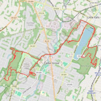
Cedar Grove
Afternoon Ride
- Distance: 24.0 Km
- Elevation gain: 401 m
- Maximum elevation: 210 m
- Elevation loss: 403 m
- Minimum elevation: 85 m
- Moving time: 2 h 52 m
- Moving speed: 8.4 Km/h
- Maximum speed: 35.1 Km/h
- Total time: 2 h 58 m
- Global speed: 8.1 Km/h
Interactive trail map
Make a donation
Gear up for your next adventure:
As an Amazon Associate, this site earns from qualifying purchases at no extra cost to you.
Trail profile
- Distance: 24.0 Km
- Elevation gain: 401 m
- Maximum elevation: 210 m
- Elevation loss: 403 m
- Minimum elevation: 85 m
- Moving time: 2 h 52 m
- Moving speed: 8.4 Km/h
- Maximum speed: 35.1 Km/h
- Total time: 2 h 58 m
- Global speed: 8.1 Km/h
Make a donation
Gear up for your next adventure:
As an Amazon Associate, this site earns from qualifying purchases at no extra cost to you.
About this trail
Name: Cedar Grove trail, distance, elevation, map, profile, GPS track
Coordinates: 40.84505 -74.25300 40.86790 -74.20634
Make a donation
Gear up for your next adventure:
As an Amazon Associate, this site earns from qualifying purchases at no extra cost to you.
Other hiking, mountain biking, running and outdoor activity trails
Click on a trail to view its statistics, map and profile.
Mills Reservation Trails
United States > New Jersey > Essex County > Montclair > Upper Montclair
Distance: 13.6 Km • Elevation gain: 240 m • Maximum elevation: 173 m
Cedar Grove Hilltop Reservation
United States > New Jersey > Essex County > Cedar Grove
Distance: 22.6 Km • Elevation gain: 400 m • Maximum elevation: 211 m
Hilltop Reservation
United States > New Jersey > Essex County > Cedar Grove
Distance: 18.4 Km • Elevation gain: 302 m • Maximum elevation: 201 m
Cedar Grove
United States > New Jersey > Essex County > Newark
Afternoon Ride
Distance: 43.1 Km • Elevation gain: 399 m • Maximum elevation: 163 m
Make a donation
Gear up for your next adventure:
As an Amazon Associate, this site earns from qualifying purchases at no extra cost to you.