Final_1dan1
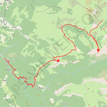
This is track no: 4
- Distance: 47.1 Km
- Elevation gain: 2,206 m
- Maximum elevation: 1,589 m
- Elevation loss: 1,036 m
- Minimum elevation: 295 m
Interactive trail map
Trail profile
- Distance: 47.1 Km
- Elevation gain: 2,206 m
- Maximum elevation: 1,589 m
- Elevation loss: 1,036 m
- Minimum elevation: 295 m
About this trail
Name: Final_1dan1 trail, distance, elevation, map, profile, GPS track
Coordinates: 43.58691 18.00541 43.67935 18.19287
Other hiking, mountain biking, running and outdoor activity trails
Click on a trail to view its statistics, map and profile.
2022_Yu
Slovenia > Ajdovščina > Žapuže
Distance: 2,457.3 Km • Elevation gain: 32,048 m • Maximum elevation: 1,950 m
Track 143
Bosnia and Herzegovina > Federation of Bosnia and Herzegovina > Ćusine > Donje Mile
8. 6. 2024 9:22 am
Distance: 346.1 Km • Elevation gain: 5,851 m • Maximum elevation: 1,228 m