Thank you for supporting this site ❤️
Make a donation
Make a donation
Gear up for your next adventure:
As an Amazon Associate, this site earns from qualifying purchases at no extra cost to you.
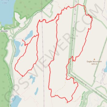
Sterling Forest State Park
Mountain Bike Ride
- Distance: 20.2 Km
- Elevation gain: 468 m
- Maximum elevation: 334 m
- Elevation loss: 469 m
- Minimum elevation: 206 m
- Moving time: 2 h 27 m
- Moving speed: 8.2 Km/h
- Maximum speed: 25.9 Km/h
- Total time: 2 h 39 m
- Global speed: 7.6 Km/h
Interactive trail map
Thank you for supporting this site ❤️
Make a donation
Make a donation
Gear up for your next adventure:
As an Amazon Associate, this site earns from qualifying purchases at no extra cost to you.
Trail profile
- Distance: 20.2 Km
- Elevation gain: 468 m
- Maximum elevation: 334 m
- Elevation loss: 469 m
- Minimum elevation: 206 m
- Moving time: 2 h 27 m
- Moving speed: 8.2 Km/h
- Maximum speed: 25.9 Km/h
- Total time: 2 h 39 m
- Global speed: 7.6 Km/h
Thank you for supporting this site ❤️
Make a donation
Make a donation
Gear up for your next adventure:
As an Amazon Associate, this site earns from qualifying purchases at no extra cost to you.
About this trail
Name: Sterling Forest State Park trail, distance, elevation, map, profile, GPS track
Coordinates: 41.17458 -74.25581 41.20588 -74.22322
Thank you for supporting this site ❤️
Make a donation
Make a donation
Gear up for your next adventure:
As an Amazon Associate, this site earns from qualifying purchases at no extra cost to you.
Other hiking, mountain biking, running and outdoor activity trails
Click on a trail to view its statistics, map and profile.
Sterling Mountain Bike Ride
United States > New York > Orange County > Town of Warwick > Lakeville
Distance: 21.2 Km • Elevation gain: 510 m • Maximum elevation: 334 m