Make a donation
Gear up for your next adventure:
As an Amazon Associate, this site earns from qualifying purchases at no extra cost to you.
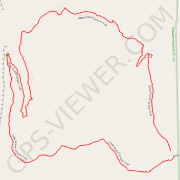
Little Grand Canyon Loop Trail in Shawnee National Forest
The Little Grand Canyon Loop Trail offers a captivating hiking experience through stunning geological formations and lush natural scenery. As you navigate the trail, you'll encounter steep cliffs, cascading waterfalls, and diverse wildlife, all of which create a vibrant atmosphere perfect for nature enthusiasts. This moderately challenging route is especially rewarding in the spring and fall when wildflowers bloom and autumn foliage adds a breathtaking touch to the landscape. #Hiking #Loop #Forest #Cliff #Waterfall #River #Nature
- Distance: 4.9 Km
- Elevation gain: 180 m
- Maximum elevation: 221 m
- Elevation loss: 180 m
- Minimum elevation: 115 m
- Moving time: 1 h 22 m
- Moving speed: 3.5 Km/h
- Maximum speed: 6.8 Km/h
- Total time: 1 h 48 m
- Global speed: 2.7 Km/h
Interactive trail map
Make a donation
Gear up for your next adventure:
As an Amazon Associate, this site earns from qualifying purchases at no extra cost to you.
Trail profile
- Distance: 4.9 Km
- Elevation gain: 180 m
- Maximum elevation: 221 m
- Elevation loss: 180 m
- Minimum elevation: 115 m
- Moving time: 1 h 22 m
- Moving speed: 3.5 Km/h
- Maximum speed: 6.8 Km/h
- Total time: 1 h 48 m
- Global speed: 2.7 Km/h
Make a donation
Gear up for your next adventure:
As an Amazon Associate, this site earns from qualifying purchases at no extra cost to you.
About this trail
Name: Little Grand Canyon Loop Trail in Shawnee National Forest trail, distance, elevation, map, profile, GPS track
Start: Little Grand Canyon Road, Jackson County, Illinois, United States (37.68044 -89.39476)
End: Little Grand Canyon Trail, Jackson County, Illinois, United States (37.68079 -89.39498)
Coordinates: 37.67959 -89.40655 37.68880 -89.39476
Make a donation
Gear up for your next adventure:
As an Amazon Associate, this site earns from qualifying purchases at no extra cost to you.