
South Loop of City Park in New Orleans
The South Loop of City Park offers a refreshing hiking experience through lush landscapes dotted with ancient oak trees and vibrant gardens. As you walk, you can enjoy views of serene lagoons, sculptures from the Sydney and Walda Besthoff Sculpture Garden, and the diverse wildlife that inhabits the area. This route combines the tranquility of nature with artistic elements, making it a perfect spot for leisurely exploration or a peaceful retreat from city life. #Hiking #Loop #Lake #Forest #Nature
- Distance: 5.8 Km
- Elevation gain: 4 m
- Maximum elevation: 5 m
- Elevation loss: 4 m
- Minimum elevation: 1 m
- Moving time: 1 h 10 m
- Moving speed: 4.9 Km/h
- Maximum speed: 6.2 Km/h
- Total time: 1 h 10 m
- Global speed: 4.9 Km/h
Interactive trail map
Trail profile
- Distance: 5.8 Km
- Elevation gain: 4 m
- Maximum elevation: 5 m
- Elevation loss: 4 m
- Minimum elevation: 1 m
- Moving time: 1 h 10 m
- Moving speed: 4.9 Km/h
- Maximum speed: 6.2 Km/h
- Total time: 1 h 10 m
- Global speed: 4.9 Km/h
About this trail
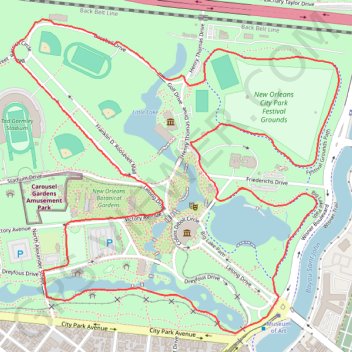
Name: South Loop of City Park in New Orleans trail, distance, elevation, map, profile, GPS track
Coordinates: 29.98326 -90.09976 29.99318 -90.08786