Tomales Point Trail in Point Reyes National Seashore
The Tomales Point Trail in Point Reyes National Seashore offers dramatic coastal views, with sweeping panoramas of both the Pacific Ocean and Tomales Bay. As you hike along the exposed bluffs, you'll encounter a variety of natural wonders, including the iconic Tule Elk, often spotted lounging in the grasslands around Windy Gap. The rugged terrain features a mix of coastal scrub, sandy stretches, and occasional steep inclines, culminating in a rewarding vista at the northern tip of the peninsula, where you can enjoy expansive views of the ocean crashing against the cliffs below. #Hiking #Island #Cliff #Coast #Nature #Pacific #Ocean #Sea
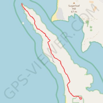
- Distance: 15.5 Km
- Elevation gain: 408 m
- Maximum elevation: 162 m
- Elevation loss: 408 m
- Minimum elevation: 0 m
Interactive trail map
Trail profile
- Distance: 15.5 Km
- Elevation gain: 408 m
- Maximum elevation: 162 m
- Elevation loss: 408 m
- Minimum elevation: 0 m
About this trail
Name: Tomales Point Trail in Point Reyes National Seashore trail, distance, elevation, map, profile, GPS track
Start: Tomales Point Trail, Marin County, California, 94953, United States (38.18913 -122.95472)
Coordinates: 38.18908 -122.99512 38.24051 -122.95402
Other hiking, mountain biking, running and outdoor activity trails
Click on a trail to view its statistics, map and profile.
Tomales Point Trail in Point Reyes National Seashore
United States > California > Marin County
The Tomales Point Trail in Point Reyes National Seashore offers hikers stunning views of the Pacific Ocean and Tomales Bay, with the opportunity to observe tule elk grazing in their natural habitat. Traversing coastal bluffs and open ridges, the trail showcases the rugged beauty of the California coastline.…
Distance: 15.4 Km • Elevation gain: 396 m • Maximum elevation: 162 m