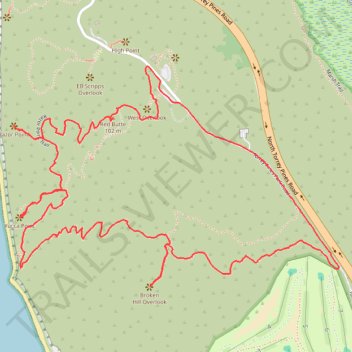
Razor Point, Yucca Point and Broken Hill Loop in Torrey Pines State Natural Reserve
The Razor Point, Yucca Point, and Broken Hill Loop in Torrey Pines State Natural Reserve offers hikers a captivating journey through diverse coastal landscapes. Along the trail, you'll encounter dramatic sandstone formations, expansive ocean vistas, and the unique Torrey pine trees, one of North America's rarest species. The path meanders through wind-sculpted badlands, providing panoramic views of the Pacific coastline and the La Jolla Peninsula, making it a memorable experience for nature enthusiasts. #Hiking #Coast #Pacific #Ocean #Sea #Nature
- Distance: 5.5 Km
- Elevation gain: 172 m
- Maximum elevation: 120 m
- Elevation loss: 172 m
- Minimum elevation: 11 m
- Moving time: 1 h 25 m
- Moving speed: 3.8 Km/h
- Maximum speed: 5.4 Km/h
- Total time: 1 h 39 m
- Global speed: 3.3 Km/h
Interactive trail map
Trail profile
- Distance: 5.5 Km
- Elevation gain: 172 m
- Maximum elevation: 120 m
- Elevation loss: 172 m
- Minimum elevation: 11 m
- Moving time: 1 h 25 m
- Moving speed: 3.8 Km/h
- Maximum speed: 5.4 Km/h
- Total time: 1 h 39 m
- Global speed: 3.3 Km/h
About this trail
Name: Razor Point, Yucca Point and Broken Hill Loop in Torrey Pines State Natural Reserve trail, distance, elevation, map, profile, GPS track
Coordinates: 32.91375 -117.25853 32.92078 -117.24616
Other hiking, mountain biking, running and outdoor activity trails
Click on a trail to view its statistics, map and profile.
Torrey Pines State Natural Reserve Loop via Guy Flemming Trail, EB Scripps Overlook, Razor Point, Yucca Point and Beach trails
United States > California > San Diego County > San Diego
Embarking on the Torrey Pines State Natural Reserve Loop via the Guy Fleming Trail, EB Scripps Overlook, Razor Point, Yucca Point and Beach trails offers hikers a diverse experience of Southern California's coastal beauty. Along the way, you'll encounter rare Torrey pine trees, dramatic sandstone cliffs, and…
Distance: 6.5 Km • Elevation gain: 244 m • Maximum elevation: 102 m
Torrey Pines Beach and Overlooks Loop
United States > California > San Diego County > San Diego
This loop hike is a delightful escape that beautifully combines stunning ocean views with charming paths. Inland, the path winds through picturesque overlooks like EB Scripps Overlook, West Overlook and Yucca Point, offering jaw-dropping ocean views. On the Beach, you'll have the chance to stroll on the sandy…
Distance: 4.9 Km • Elevation gain: 151 m • Maximum elevation: 102 m