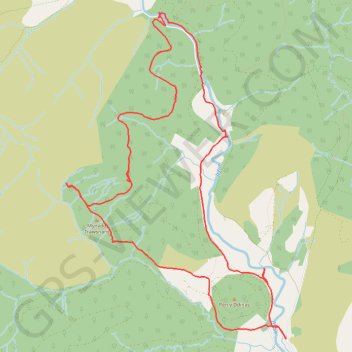
Irfon Forest
- Distance: 14.6 Km
- Elevation gain: 456 m
- Maximum elevation: 480 m
- Elevation loss: 457 m
- Minimum elevation: 215 m
- Moving time: 4 h 7 m
- Moving speed: 3.5 Km/h
- Maximum speed: 5.6 Km/h
- Total time: 5 h 50 m
- Global speed: 2.5 Km/h
Interactive trail map
Trail profile
- Distance: 14.6 Km
- Elevation gain: 456 m
- Maximum elevation: 480 m
- Elevation loss: 457 m
- Minimum elevation: 215 m
- Moving time: 4 h 7 m
- Moving speed: 3.5 Km/h
- Maximum speed: 5.6 Km/h
- Total time: 5 h 50 m
- Global speed: 2.5 Km/h
About this trail
Name: Irfon Forest trail, distance, elevation, map, profile, GPS track
Start: Llanwrtyd Wells, Powys, Wales, LD5 4SY, United Kingdom (52.11526 -3.65821)
End: Llanwrtyd Wells, Powys, Wales, LD5 4SY, United Kingdom (52.11521 -3.65820)
Coordinates: 52.11514 -3.69530 52.14897 -3.65797
Other hiking, mountain biking, running and outdoor activity trails
Click on a trail to view its statistics, map and profile.
The Headstock 500
United Kingdom > Wales > Newport > Newport
Distance: 483.5 Km • Elevation gain: 9,616 m • Maximum elevation: 691 m
Nant Gwyn
United Kingdom > Wales > Powys > Llanwrtyd Wells
Distance: 11.6 Km • Elevation gain: 396 m • Maximum elevation: 439 m