Make a donation
Gear up for your next adventure:
As an Amazon Associate, this site earns from qualifying purchases at no extra cost to you.
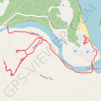
Ludington State Park
Hike through Ludington State Park along Big Sable River between Hamlin Lake and Lake Michigan via Hamlin Dam. #Hiking #Nature #Park #Forest #River #Lake #Dam
- Distance: 2.8 Km
- Elevation gain: 35 m
- Maximum elevation: 195 m
- Elevation loss: 33 m
- Minimum elevation: 180 m
- Moving time: 1 h 1 m
- Moving speed: 2.8 Km/h
- Maximum speed: 12.5 Km/h
- Total time: 1 h 15 m
- Global speed: 2.3 Km/h
Interactive trail map
Make a donation
Gear up for your next adventure:
As an Amazon Associate, this site earns from qualifying purchases at no extra cost to you.
Trail profile
- Distance: 2.8 Km
- Elevation gain: 35 m
- Maximum elevation: 195 m
- Elevation loss: 33 m
- Minimum elevation: 180 m
- Moving time: 1 h 1 m
- Moving speed: 2.8 Km/h
- Maximum speed: 12.5 Km/h
- Total time: 1 h 15 m
- Global speed: 2.3 Km/h
Make a donation
Gear up for your next adventure:
As an Amazon Associate, this site earns from qualifying purchases at no extra cost to you.
About this trail
Name: Ludington State Park trail, distance, elevation, map, profile, GPS track
End: Bike Path, Hamlin Township, Mason County, Michigan, United States (44.03440 -86.49265)
Coordinates: 44.03202 -86.50095 44.03551 -86.49179
Make a donation
Gear up for your next adventure:
As an Amazon Associate, this site earns from qualifying purchases at no extra cost to you.
Other hiking, mountain biking, running and outdoor activity trails
Click on a trail to view its statistics, map and profile.
Hike to Inspiration Point
United States > Michigan > Mason County
Distance: 2.7 Km • Elevation gain: 51 m • Maximum elevation: 209 m