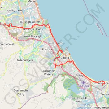
Gold Coast - Coolangatta
#Bike
- Distance: 29.4 Km
- Elevation gain: 196 m
- Maximum elevation: 28 m
- Elevation loss: 204 m
- Minimum elevation: -2 m
Interactive trail map
Trail profile
- Distance: 29.4 Km
- Elevation gain: 196 m
- Maximum elevation: 28 m
- Elevation loss: 204 m
- Minimum elevation: -2 m
About this trail
Name: Gold Coast - Coolangatta trail, distance, elevation, map, profile, GPS track
Start: Station Road, Varsity Lakes, Gold Coast City, Queensland, 4227, Australia (-28.09688 153.39955)
End: Jarvis Lane, Coolangatta, Gold Coast City, Queensland, 2485, Australia (-28.17133 153.53677)
Coordinates: -28.17133 153.39955 -28.09542 153.53965
Other hiking, mountain biking, running and outdoor activity trails
Click on a trail to view its statistics, map and profile.
Burleigh Head National Park - Tumgun Lookout
Australia > Queensland > Gold Coast City
Distance: 3.3 Km • Elevation gain: 122 m • Maximum elevation: 71 m