Thank you for supporting this site ❤️
Make a donation
Make a donation
Gear up for your next adventure:
As an Amazon Associate, this site earns from qualifying purchases at no extra cost to you.
Rosy Mound Natural Area
Foot
- Distance: 2.2 Km
- Elevation gain: 32 m
- Maximum elevation: 212 m
- Elevation loss: 28 m
- Minimum elevation: 181 m
- Moving time: 40 m 33 s
- Moving speed: 3.3 Km/h
- Maximum speed: 9.8 Km/h
- Total time: 54 m 58 s
- Global speed: 2.4 Km/h
Interactive trail map
Thank you for supporting this site ❤️
Make a donation
Make a donation
Gear up for your next adventure:
As an Amazon Associate, this site earns from qualifying purchases at no extra cost to you.
Trail profile
- Distance: 2.2 Km
- Elevation gain: 32 m
- Maximum elevation: 212 m
- Elevation loss: 28 m
- Minimum elevation: 181 m
- Moving time: 40 m 33 s
- Moving speed: 3.3 Km/h
- Maximum speed: 9.8 Km/h
- Total time: 54 m 58 s
- Global speed: 2.4 Km/h
Thank you for supporting this site ❤️
Make a donation
Make a donation
Gear up for your next adventure:
As an Amazon Associate, this site earns from qualifying purchases at no extra cost to you.
About this trail
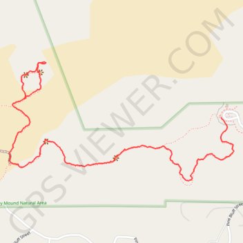
Name: Rosy Mound Natural Area trail, distance, elevation, map, profile, GPS track
Coordinates: 43.01859 -86.23225 43.02275 -86.22152
Thank you for supporting this site ❤️
Make a donation
Make a donation
Gear up for your next adventure:
As an Amazon Associate, this site earns from qualifying purchases at no extra cost to you.