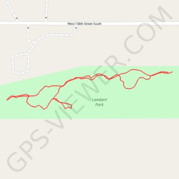
Lambert Trail
- Distance: 0.8 Km
- Elevation gain: 5 m
- Maximum elevation: 215 m
- Elevation loss: 5 m
- Minimum elevation: 210 m
- Moving time: 11 m 18 s
- Moving speed: 4.2 Km/h
- Maximum speed: 6.0 Km/h
- Total time: 11 m 18 s
- Global speed: 4.2 Km/h
Interactive trail map
Trail profile
- Distance: 0.8 Km
- Elevation gain: 5 m
- Maximum elevation: 215 m
- Elevation loss: 5 m
- Minimum elevation: 210 m
- Moving time: 11 m 18 s
- Moving speed: 4.2 Km/h
- Maximum speed: 6.0 Km/h
- Total time: 11 m 18 s
- Global speed: 4.2 Km/h
About this trail
Name: Lambert Trail trail, distance, elevation, map, profile, GPS track
Start: Lambert Path, Glenpool, Tulsa County, Oklahoma, 74033, United States (35.96352 -96.01270)
End: Lambert Path, Glenpool, Tulsa County, Oklahoma, 74033, United States (35.96351 -96.01278)
Coordinates: 35.96292 -96.01596 35.96356 -96.01270