Make a donation
Gear up for your next adventure:
As an Amazon Associate, this site earns from qualifying purchases at no extra cost to you.
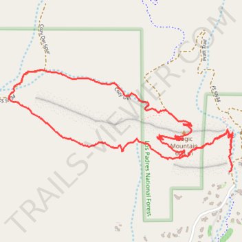
Magic Mountain Loop via Foothill Trail and Cozy Del
- Distance: 5.2 Km
- Elevation gain: 277 m
- Maximum elevation: 598 m
- Elevation loss: 294 m
- Minimum elevation: 439 m
- Moving time: 1 h 10 m
- Moving speed: 4.4 Km/h
- Maximum speed: 18.4 Km/h
- Total time: 1 h 10 m
- Global speed: 4.4 Km/h
Interactive trail map
Make a donation
Gear up for your next adventure:
As an Amazon Associate, this site earns from qualifying purchases at no extra cost to you.
Trail profile
- Distance: 5.2 Km
- Elevation gain: 277 m
- Maximum elevation: 598 m
- Elevation loss: 294 m
- Minimum elevation: 439 m
- Moving time: 1 h 10 m
- Moving speed: 4.4 Km/h
- Maximum speed: 18.4 Km/h
- Total time: 1 h 10 m
- Global speed: 4.4 Km/h
Make a donation
Gear up for your next adventure:
As an Amazon Associate, this site earns from qualifying purchases at no extra cost to you.
About this trail
Name: Magic Mountain Loop via Foothill Trail and Cozy Del trail, distance, elevation, map, profile, GPS track
Start: Stewart Canyon Trail, Ventura County, California, 93023, United States (34.47153 -119.25303)
End: Foothill Road, Ventura County, California, 93023, United States (34.47010 -119.25316)
Coordinates: 34.47010 -119.26878 34.47606 -119.25291
Make a donation
Gear up for your next adventure:
As an Amazon Associate, this site earns from qualifying purchases at no extra cost to you.
Other hiking, mountain biking, running and outdoor activity trails
Click on a trail to view its statistics, map and profile.
Valley View Preserve
United States > California > Ventura County > Ojai
Distance: 8.4 Km • Elevation gain: 517 m • Maximum elevation: 555 m